

Marine
Our Marine department we offer a broad range of capabilities in marine surveying and consulting, GIS and remote sensing and project management within the marine industry. Our team is composed of experienced scientists, marine technicians and scientific divers, whose expertise cover several disciplines that enable us to provide support to a broad range of marine research, conservation and exploration activities.
A wide range of in-house surveying equipment is available at our Marine department to carry out projects for private clients, governmental agencies or as part of EU funded projects.
Oceanographic Surveys
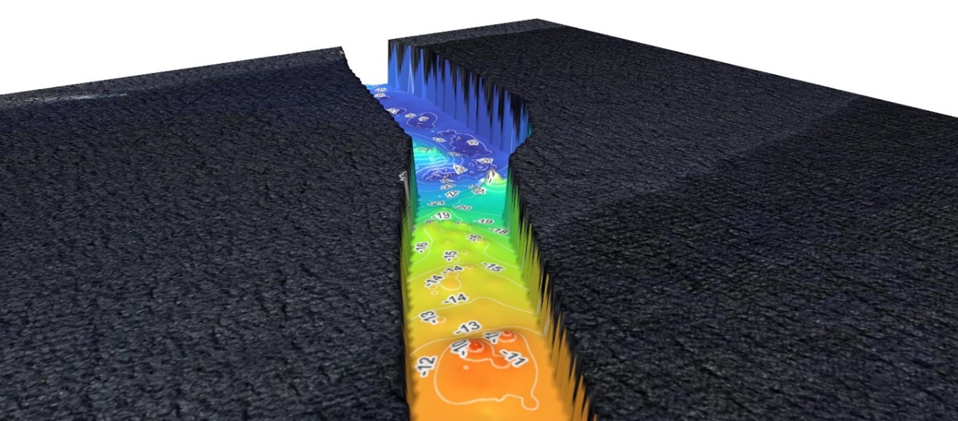
Our Marine expertise offers fully comprehensive benthic habitat mapping services which utilise interferometric swath bathymetry systems and Side Scan Sonar (SSS). All surveys are performed by a team of experienced scientists and marine technicians, and data gathered is processed via GIS or other specialised software, to produce a detailed flat, monochromatic representation of the surveyed area, ideal for detailed examinations of the seabed. Bathymetric data may also be visualised accurately as a 2D or 3D colour-coded depth profile of the seabed.
ROV Inspections
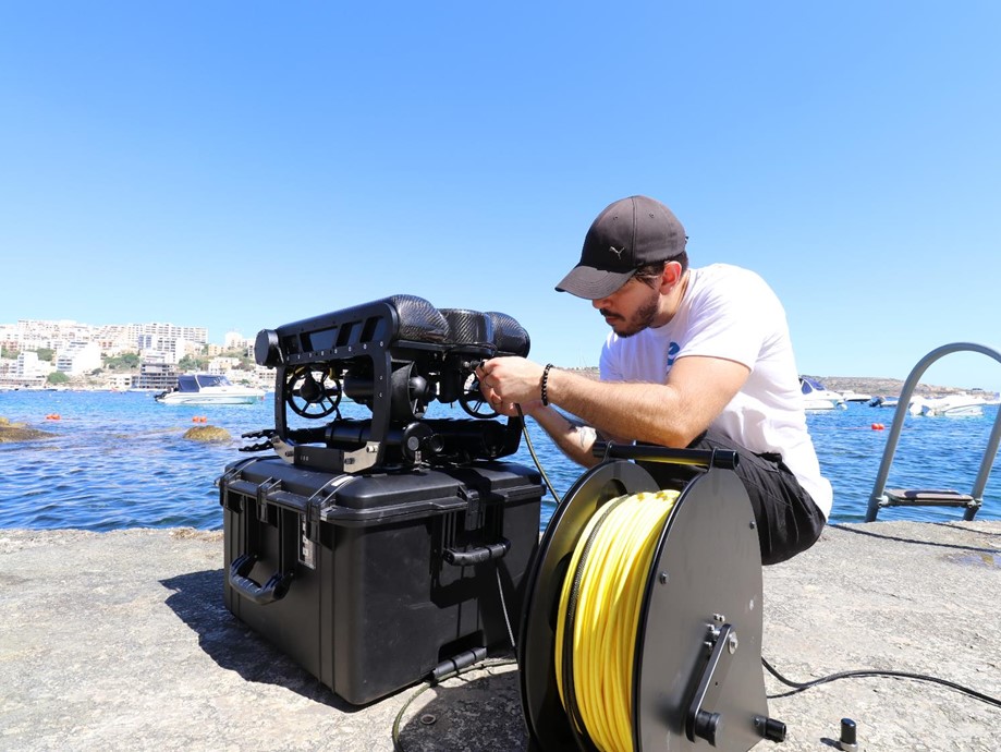
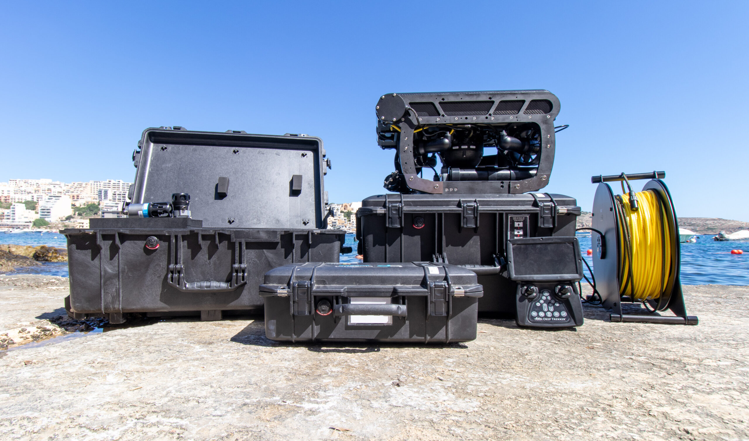
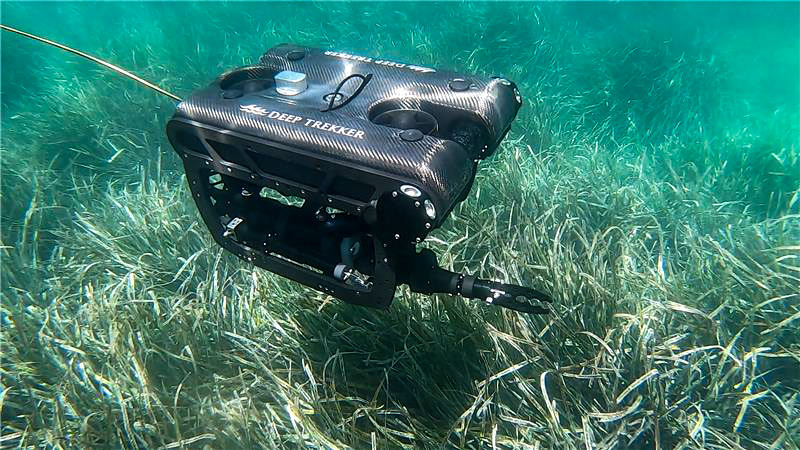
The Marine department houses a Remotely Operated Vehicle (ROV) capable of reaching depths up to 300m. The in-house ROV is updated with the latest technology, comprising of a 4K camera enabling the capture of high-quality marine footage, as well as 6 powerful thrusters that provide further stability, making underwater inspections and optical surveys steadier than ever. It comes equipped with a two-function grabber arm, an optional sediment grabber and water sampler, as well as a tool platform capable of hosting additional marine sensors. The ROV is an excellent multi-tool capable of performing habitat mapping, site assessments, and search and recovery for anchors and chains.
Ecological Monitoring and Research
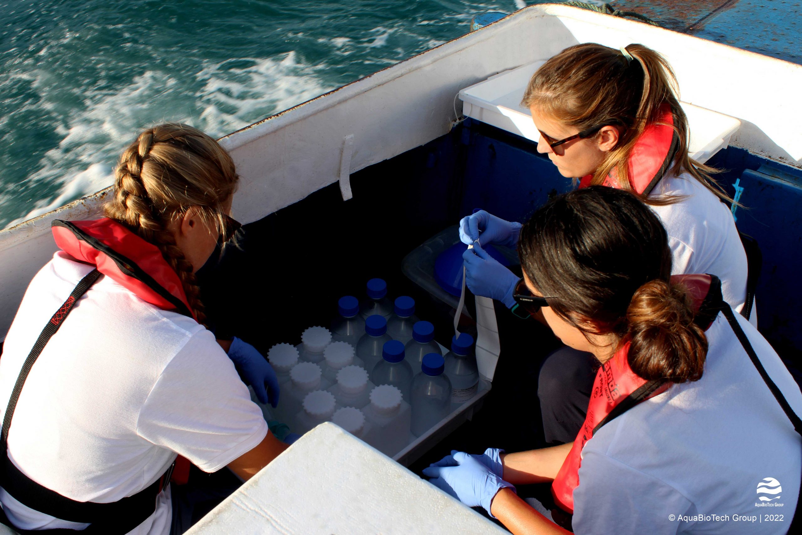
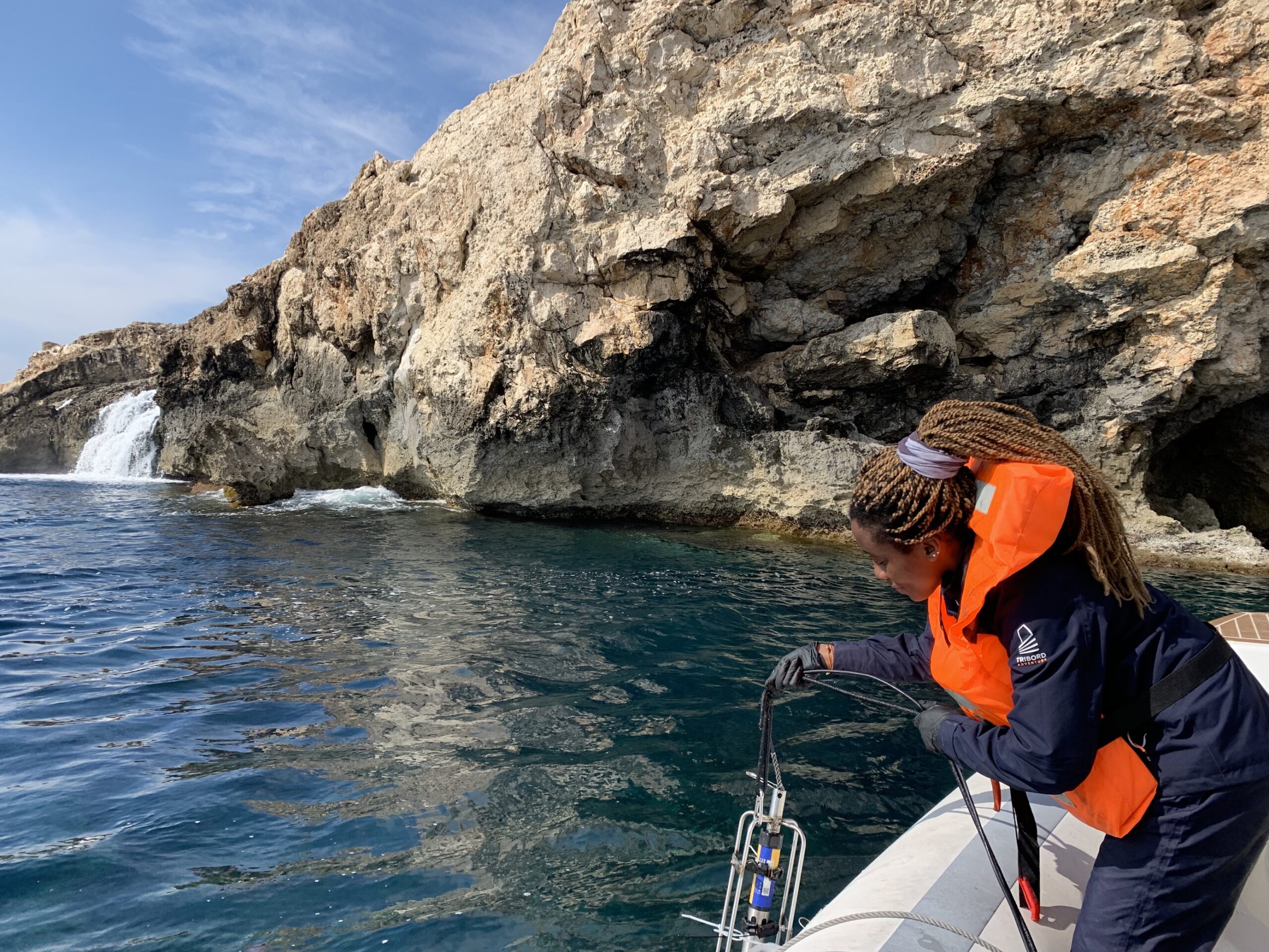
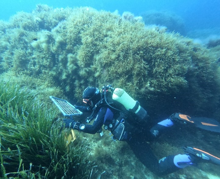
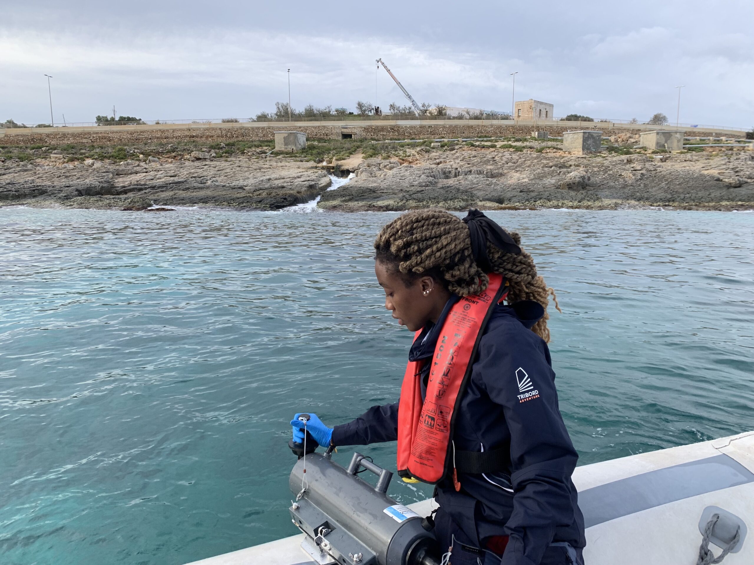
Our team of scientific divers and technical experts combined with our wide range of in-house equipment provide the skills and tools necessary to perform routine ecological monitoring. Our multi-parameter sonde enables the measurement of physical parameters along the water column, while Niskin bottles allow for the collection of water samples, which together provide a comprehensive ecological assessment. We also offer macrobenthos, phytoplankton and zooplankton sorting, identification and data processing.
Subsea sediment sampling
We offer a complete service for seabed sediment analysis. Sub-bottom profiling surveys, sediment grabs via a Van Veen grab, and core extraction provide information on the stratification, grain size and chemical characteristics of the seabed. We are actively cooperating with an ISO Accredited Laboratory and can therefore offer sediment analysis according to industry standards.
Consultancy and Advisory
Marine also offers consultancy expertise, consisting of but not limited to the following:
- Environmental Impact Assessment (EIA)
- Marine Baseline Environmental Reports (MBES)
- Preliminary Reconnaissance Marine Surveys (PRMS)
- Environmental Monitoring and Management Plans
- Marine Protected Areas (MPA) management
- GIS for marine applications and spatial planning
Other Services
Furthermore, we can offer services to the following industries:
- Marine Construction
- Data Confirmation and Site Inspections
- Marine Archaeology
- Search and Rescue
Project references
 |
Marine Environmental Investigations at Grand Harbour, Valletta |
|
| The purpose of this study was to conduct marine environmental investigations at the Grand Harbour, Valletta. These investigations served as baseline studies for a variety of planned construction and development projects within the Grand Harbour. In detail, a marine ecology baseline survey was performed including desktop studies, scientific SCUBA diving, ROV inspections and infauna surveys to map benthic assemblages at different sites in the harbour. In total, nine study areas throughout the Grand Harbour were assessed, covering large parts of the harbour’s area. Additionally, water quality sampling was performed at several stations within the harbour. | ||
| Sponsor: Duration: |
Infrastructure Malta March 2020 – February 2021 |
|
  |
Service Tender for Surveys to Assess the Impacts of Anchoring/Mooring Activity, and the Socio- Economic Assessment of Management Options |
|
| This project surveys the extent of anchoring and mooring activities in Malta’s territorial waters with a view to assess the levels of impacts from such activities and identify relevant management options on the basis of technical feasibility and a socio-economic assessment. AquaBioTech Group has conducted AIS surveys to assess the extent of anchoring and mooring activity across select Maltese bays, followed by ROV surveys and SCUBA dives to determine and quantify the impacts of anchoring/mooring activities on seabed habitats through localised and targeted surveys. The project furthermore identifies and prioritises management options to address the identified impacts on seabed habitats on the basis of a technical feasibility and socio-economic assessment.
More information on the above project, please refer here |
||
| Sponsor: Tender Ref: |
Environmental & Resources Authority GF/Admin 11/2020 |
|
| Life Project: | LIFE 16 IPE MT008 project, Optimising the implementation of the 2nd RBMP in the Malta River Basin District | |
 |
Impact of Revers Osmosis Discharges on the Marine Environment |
|
| The project aims to provide a study capable of creating a clear picture of the impact that brine discharge from Sewage Water Reverse Osmosis (SWRO) plants are having on the marine environment. Throughout the duration of the project, AquaBioTech is mapping the area of influence of brine discharges from the SWRO, as well as investigating and identifying any impact that this discharge may have on the marine environment. The scope of the project is also to develop a comprehensive monitoring programme to ensure that the marine habitat is protected. | ||
| Contractor: Project Ref: |
Water Services Corporation WSC/T/80/2021 |
|
Electrical Interconnector 2 - Preliminary Marine Route Survey and Post Survey Studies |
||
| The Italy-Malta IC2 project objective is the installation of a cable that will allow Malta to import electrical energy, including renewable energy, from the European electricity grid (physical structures that enable electricity to be traded across borders). It will ensure that Malta still complies with the environmental and climate change obligations by importing energy from sources emitting less greenhouse gases. | ||
| Contractor: Duration: |
Interconnect Malta (ICM) March 2022 – August 2023 |
|
Marine & RDI Projects
 |
AutonoMous Bio-mimetic Underwater vehicLe for digitAl cage monitoring | AMBULANT | |
| The project aims to develop a dynamic monitoring system of deep-water cages through the implementation of a submersible robot carrier based in China, which will be achieved by the designing and construction of an innovative bionic underwater robotic system. This system will incorporate a spatiotemporal prediction model for water quality in marine environments and aquaculture, along with a Biomass Estimation model for fish biomass estimates and construct an automated benthic detection and identification system of key marine features through machine learning, machine vision prototypes and artificial neural networks. AquaBioTech’s role in this project is the data collection of footage relating to benthic habitats across Maltese territorial waters via an ROV, along with manual data labelling of each species present in the data. This data will then be trained by partners MCAST into an automated classification system capable of identifying benthic species through live footage. AquaBioTech aims to conduct a demonstration in Malta for the benthic habitat model for live identification of Maltese marine benthic habitats from ROV captured video in the depth range between 10-100 meters. | ||
| Project Details: Duration: |
Ambulant October 2022 – October 2024 |
|
| Blue Culture Technology Excellence Hubs in EU Widening Member States | BCTHubs | |
| BCThubs project aspires to build R&I capacities in the Blue Economy sector of the participating Widening countries, focusing on Blue Culture Technologies (BCT) supporting the Underwater (UW) Cultural Heritage (CH) scientific research and tourism valorization. Although the European seas are rich in UWCH sites and assets, only a few of them are exploited sustainably towards social welfare, cohesion and growth. BCThubs aims to build BCT Excellence Hubs supporting new innovative solutions and products, the sustainable protection, restoration, valorisation, management, accessibility and promotion of UWCH. AquaBioTech’s involvement in this ambitious project is to help develop the Maltese hub ecosystem, implement a detailed mapping system of existing quadruple helix stakeholders, and integrate upskilling and networking for stakeholders. | |
| Project Details: BCTHubs Duration: January 2023 - December 2026 |